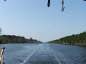
An American ICW view in October
Living the Dream
Six moons in the USA
Month 5
6 to 31 October 2007
On the Atlantic Intracoastal Waterway (ICW)
For those of our friends and relatives who have never ventured upon or heard of the ICW, I would like to give you an abridged description of this incredible and imaginative feat of American engineering. Starting at “Mile Zero” in the Elizabeth River, which runs between the cities of Norfolk and Portsmouth in Virginia, the waterway travels south for about 1 100 miles to the south of Florida. It passes through rivers, creeks, swamps, canals, bays, lakes and sounds, which stretch along inside the very low contoured east coast of the United States. The depth of the channels through these bodies of water, dredged by the US Army Corps of Engineers is generally 12 feet, but this can be severely reduced at junctions with inlets, rivers and bays due to silting. Moreover, many parts of the ICW have not been dredged for five years because environmental groups have protested about the dumping of silt and the disturbance of bottom growth creatures. Our draft is 2 metres (6'6''), so most of the time we are sailing along with 1.7 metres (5'6'') under our keel, but one watches the depth sounder readings constantly and with some trepidation, especially when it reads below 1 metre.
You should be made aware, as we were not and accordingly had been completely oblivious that the countryside behind the east coast of the USA south of Boston does not rise above 50 feet in height. Great stretches of the coast consists of barrier islands, which from seaward resemble large sand dunes. The New Jersey coastline, for example, is covered without a break with beach houses, which seem totally unprotected from Atlantic storms, sitting as they do on top of the dunes. We, in Europe, are accustomed to seeing headlands rising hundreds of feet above sea level and ocean capes, which are easily avoided because they can be seen from miles away. The capes in the USA, which strike terror into the sailor with names like Cape Fear, can hardly be seen, but amount to shoals stretching some tens of miles out from the coast and which can be equally as dangerous.
The main advantage of the ICW is that it can be used all year round to avoid the Atlantic storms and even in the event of hurricanes, there are hurricane holes just off the ICW in which one can attempt to shelter. Many Canadians and Americans use this route to travel to and from the sunny climes of Florida and the Caribbean, travelling south in the fall and north in the spring. They are known colloquially as “Snowbirds,” and tend to head down the ICW from the beginning of November. We are deliberately travelling south ahead of them as they tend to gather in fleets. Thus, anchorages and marinas can be filled by one group alone.
Bascule bridges
As these channels pass through various areas of human habitation, there are necessarily road and railway bridges. Some are fixed with arches over the ICW, others are bascule bridges or swing bridges and each of these have their own particular problem, which I will briefly describe. The charts show the clearance of both bridges and overhead power cables.
The fixed bridges can be as low as 65 feet at low tide. This is no problem for us as our mast is only 57 feet high, but when one passes underneath them, that 8 feet of gap shrinks visually and it doesn’t half look close to touching. One American yacht, which we encountered while waiting for a bridge to open had a mast of 63.5 feet, which, for me, would have been a little bit too much touchy feely. Needless to say he passed through very slowly.
The other bridges open on the hour or half hour or both and so one has to time one’s trip in between them to arrive just in time. We have not found any of the bridges to be a particular problem, because we call the bridge tenders up ahead of time and verify that we can pass through. The bridge tenders have been very polite and helpful, as we have found most American officials.
To gauge how far one has travelled along the route, there are markers on wooden posts, informing us of the statute mile along the ICW. For example, as I am writing this, we are close to mile marker 670, indicating that we have travelled 670 statute (land) miles along the ICW.
We stayed in the anchorage at “Mile Zero” in Portsmouth for four days from 5 to 9 October and visited Norfolk on the other side of the Elizabeth River, walked miles and enjoyed our visits to the Chrysler Art Gallery and the Argentinian sail training ship “Libertad”. We were awoken early one morning by a super cruise ship tying up on the other side of the river in the fog and manoeuvring close to our anchorage with its bow thrusters as if it was a 30-foot yacht inside of a 600-foot cruise liner.
I took advantage, while stationary for this short period, to visit a local American dentist, who was very professional and completed some emergency work on a filling and bridge on my teeth, which had been plaguing me recently.
Well done, Siobhán!
We reprovisioned and topped up with water and diesel in readiness for motoring on the ICW and checked the timings of the bridges for our first day in the ICW and went to bed early for an early start the next morning.
So, without more ado, we will set out along the course of the ICW on this new adventure. We raised the anchor in Portsmouth at 0745, but then spent 15 minutes cleaning the 30 metres of chain of the syrupy mud covering it. Then motored swiftly along to the first of our bridges for the day: the N&P Beltline Rail Bridge. During our first morning we passed the following bridges: Jordan Lift Bridge; Norfolk and Western Rail Bridge; Gilmerton Bascule and Gilmerton N&WR Rail Bascule Bridge; Steel Bridge; Great Bridge Lock and Great Bridge, Bridge 13 (65' fixed…..oooer) and Centerville Turnpike Swingbridge; and all before 1230.
Towards the end of the afternoon, we were intending to anchor at Pungo Ferry Bridge, but as soon as we headed towards the anchorage, our depth sounder went to 0.5 metres(19 inches), so we reversed out and headed for Blackwater Creek, which produced the same result, so we motored on and finally moored at Coinjock Marina alongside the canal.
Siobhán removes 14 lads following an invasion
Later that evening, Siobhán removed 14 lads (dead flies) after we had fumigated the sleeping accommodation, following an invasion. These invasions are not regular, but have occurred from time to time and involved different sized flies, which have not been bothersome to us but make one feel lousy. We have found that our anti-midge screens have been thoroughly efficient at keeping the biting blighters at bay, provided we click them in as its getting dark and not later. As we were getting ready for bed after our longer than anticipated day, we were surprised by the repetitive whooshing sound of water outside the boat and found flocks after flocks of mallard ducks landing on the canal, seemingly under the directions of a very vociferous lead duck.
This was just another example of our great fortune at being so close to nature all the time. Virtually every day, we see or hear birds or animals in their natural environment, which we have not experienced before. Oh! for a more powerful lens for our camera to be able to shoot them for posterity.
On the following morning we rose late, showered ashore, breakfasted and then cast off at Coinjock Marina at 0950. Shortly afterwards, we tried sailing with the working jib out with 9 knots of wind on a broad reach and at 1230 entered Albemarle Sound, having passed mile markers, 55, 60, 65 and 70. We were heading for an anchorage at the entrance to Little Alligator River, but found that the actual anchorage was so far from the shore, which was low lying anyway, that it would have given us no shelter whatsoever. We then headed across the bay and finally anchored behind Durant Island, but even so this was not a well protected bolt hole as we were in 1.7 metres of water. Moreover, as we were approaching our chosen spot, the boat became the landing strip for many species of tiny and very small flies. We shut down the hatches as soon as we could.
We were awoken early the following morning by a rising wind. Having checked the deck that all was well, we returned to bed and slept till 0800. We rose and raised the anchor and caught the Alligator River Swing Bridge opening on time and sailed pleasantly down the Alligator River, passing mile markers 85, 90, 95, 100, 105 and 110 and entering the Alligator River-Pungo River Canal in the early afternoon. This canal is lined on both sides by cypress swamps, some of which are in a petrified condition. It was a beautiful day with a perfectly cloudless azure sky and light winds. There are no inhabitants living along the bank, so it was just nature, “Light Blue” and us in peace and tranquillity.
One had to be careful as one navigated along this completely straight stretch as there are tree stumps poking out above the water. The fast moving motor boats kick up such a wake that they destroy the banks, the trees fall into the canal and lie beneath the surface. We had one experience where we were motoring along an apparently clear section when our keel pushed on a tree lying underwater and this pushed a 12 foot long branch right out of the water beside the boat. No damage done.
Words and Wine and Woman.
We finally left the canal and anchored in 1.1 metres of sheltered water behind Satterthwaite Point. It was so peaceful here that we stayed two nights. On the second day we spent most of it down below, relaxing, reading and tidying up the saloon and forepeak and doing little niggling but necessary jobs. We were buzzed by a local fisherman in his flat fishing boat, who circled us a couple of times. I went up on deck and he told me that some locals ashore were worried about us, as they hadn’t seen us all day. I explained that we had just been pottering and he understood. I thanked him for his concern.
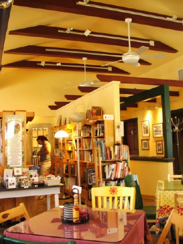
Our next day of travel ended after six hours of motoring in an anchorage off Belhaven, a charming bourg, which was reminiscent of some Hollywood film of the 1930s and we felt that we were finally heading into the south, if not the deep south. We found a delightful restaurant cum book shop cum wine shop called “Wine and Words”, which was run by a very friendly lady from Wimbledon in south-west London. We enjoyed a healthy lunch, washed down by rich barley wine ale and purchased a couple of second-hand books.
Reading fills a large portion of our relaxation time, when we are sailing and when at anchor. We generally have at least three books on the go at one time, one of which I am reading to Siobhán and individual books, which we read ourselves. Without planning, we have selected our current reading material to include the area through which we have been passing. Most of the marinas we have visited have had book-swop corners, so we can dispose of our completed reading and gather new, without depleting the coffers. Local libraries are another excellent source of hardback and paperback books, selling them at a $1 (50p) or 50 cents (25p) respectively.
From Belhaven we traversed to Broad Creek
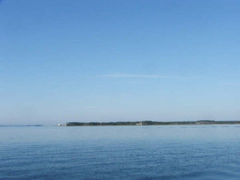
Moving along ever southwards we cross large lakes perhaps four miles across and rivers a mile wide, bordered by low-lying tree-lined banks, through which we must keep to a narrow (30-metre) shallow passage, forever watching the depth gauge. It is a strange restricted voyage, without the normal ocean freedom to which we have been accustomed. From Belhaven we traversed to Broad Creek and were escorted to our anchorage by several dolphins and the following morning escorted out again by the same pod. This was to be the first of many sightings of dolphins obviously surviving within these muddy inland waters. They appear very slow, shy and lethargic compared to their ocean cousins and do not race alongside the bows, but rise to the surface once or twice and then disappear.
Beaufort, North Carolina, was our next destination and was one of our civilised marina stops, where we paused for a couple of days to catch our breath and found it to be nothing as we had imagined. Tied up at the city docks, we were surrounded by four 70-foot luxury ocean fishing boats, returning from the Annapolis Boat Show. During the time we were there we saw them all taking on fuel, with one of them taking on 1 900 gallons of fuel
The recent hike in fuel costs in the USA must be a massive deterrent to motor boaters, as we have known the marina cost rise from US$2.50 to US$3.80 per gallon since we have been here. Naturally we find it very cheap coming from England, with prices at US$10 per gallon, but the Americans cannot get over the shock. Who knows, perhaps the US Government is attempting to reduce the number of stinkpots in the world to fall in line with the Kyoto Treaty.
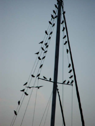
A murder of crows in Charleston
Beaufort, NC ( pronounced Bowfort) should not be confused with Beaufort, SC (pronounced Bewfort with a dubbleya as in ICW). They are as different as chalk and cheese, but equally as interesting to foreign tourists as Siobhán and me, as every day in the United States is for us.
Approaching the harbour we had to pass so closely to the inlet from the Atlantic, that the wind was fresher, the water crystal clean and the quality of the light reminiscent of the clarity one sees in the Caribbean. The spume was vibrant white as opposed to muddy brown and it was so tempting to press on out of the inlet to the freedom of the ocean again.
After a day of land life we were on our way again travelling down the ICW and finally anchoring in a bizarre man-made lagoon called Mile Hammock Bay, which is located within the area used by the US marines for training. Several times during the evening, the bay was buzzed by a fixed-wing/helicopter troop carrier, which was practising landing in the jungle and then taking off again. Eventually, as it became dark the flights ceased and we resumed our quiet life in the anchorage.
The following morning we were off again, this time to Wrightsville, as we had seen the film and read the book “Message in a Bottle” and being thorough romantics we wanted to visit the scenes mentioned in the book. But it was not to be, as the Wrightsville we visited was very commercial and we had to rest upon our idealistic memories.
Dutchman’s Creek
The bracing ocean air had lured us to plan an outside stage on our southbound trip and we motored down until we were anchored in Dutchman’s Creek just behind Cape Fear, so that we would be ready to exit alongside the cape at the next high tide the following morning. With anchor snug in its bow roller at 0645, we headed past the portentous cape peacefully and without mishap and headed out for our first 24-hour voyage in several months. The whole of our trip was passed comfortably with easterly force 4/5 winds followed by south-easterly force 4.
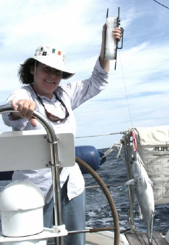
For the first morning, with full main and lightweight goose-winged we floated along calmly and then changed to broad reach “creaming along at 6.5 knots with a following swell”. It was such a pleasant contrast to the constant concentration on the ICW, that Siobhán trolled two fishing lines behind. We had purchased a telescopic net to pick up items of interest passing us. We netted some spored and seeded seaweed, among the fronds of which we found a small fish, which we returned alive to the deep, after photographs had been taken.
Shortly after, we recovered one of the fishing lines with Siobhán’s largest catch yet. After giving it the coup de grâce with a large tot of Jameson whisky, I topped and tailed and filleted this large king fish, whose large meaty fillets provided us with several delicious meals. Well done, darling.
During the night we slowed the rig so that we would arrive in the anchorage in Ashley River in Charleston in the early morning and sure enough, we splashed our very efficient Bruce anchor into the harbour at 0815 on 21 October.
Generally, we anchor wherever we can, because it is free and there is less chance of damage than in a marina. We use marinas only when necessary and at the same time as we do this, we use their courtesy car to replenish our food stocks and propane gas, use their laundromat and fill up with diesel and water at the same time. Plugging into their 50-amp shore power tops up our service, engine and navigation batteries. With marina charges varying from $1 to $5 per foot (US$38 (£19) to US$190 (£95)) per night, we always check ahead to find the cheapest and most comprehensive marina.
We stayed in Charleston anchorage until 27 October and did in this beautiful southern city probably the same as most other tourists, who become enchanted with the shady avenues, streets and residential walkways. We dallied and soaked up the ambience, initially at lunchtime in one of the central restaurants, filled with the university students, lawyers, business folk and tourists. We were further charmed by the beauty of the mansions, town houses and public buildings, which have been preserved by the families dwelling within them. Each building carried a plaque at the entrance certifying that the house had been refurbished within and restored without to its former glory.
Slow boat from China
One of the features we found particularly charming was the enclosed porch, which runs along the side elevation of the house, the entrance to which appears to be the front door, whereas, in reality, the front door to the accommodation was halfway along the porch itself. I have enclosed a photograph of one such, to elaborate on my rather clumsy description.
The whole city is steeped in the history surrounding the American Civil War, which ran its course in the 1860s, and culminated in the government of the northern states holding sway over the whole of the United States. Charleston and its environs was involved fully in this struggle between north and south, by the building of defence forts facing seaward around the Atlantic entrance to the harbour and its three important rivers, the Ashley, Cooper and Wando.
Of these forts, none played a more strategic part than Fort Sumter, which we visited upon the tourist ferry and enjoyed both the inboard commentary and wandering about the battlements and fortifications. The photographs and the narratives in the museum brought home to us the fact that this struggle took place only 150 years ago. Moreover, it enabled us to visualise the personalities involved, which lent a personal side to what otherwise would have been a piece of distant history. Most of the influential people involved were after all European in descent at that point in history.
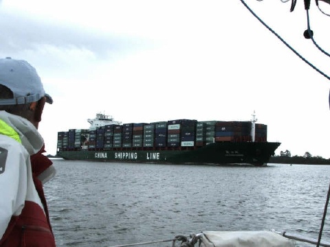
Chinese imports to USA on the Savannah River
Our American voyage of discovery continues to astound us, as we gain a far better picture of this sub-continent’s rich chronicle. Its 400 years of current history is still unfolding, as its peoples composed of settlers, slave descendants and illegal immigrants recognise themselves almost immediately generically as Americans, while holding onto their original roots.
To complete our fifth month in the United States we could not have chosen a better place than Beaufort, South Carolina, where we spent two days soaking up the southern hospitality and then Savannah, where we anchored in the Herb River, just south of Thunderball marina. Interestingly, as we were crossing the Savannah River, we had to give way to a massive container ship heading up river, which was carrying over 1 500 containers, all from China.
We have found that in the supermarkets, many of the items on sale have been manufactured in China. Americans to whom we have spoken have registered their disgust with the move away from being a manufacturing nation. We find their relationship with China as strange as China is probably one of the strictest communist countries in the world and yet the US government trades openly with them, whereas they will not trade with Cuba, only a 100 miles from their south coast. Yet another example of unexplainable behaviour in this strangest of countries.
So we now approach our last month in the United States and we have now decided to go to Cuba on leaving at the end of November, if the fates are with us. We have to time our leaving in conjunction with the dictates of the insurance company, which warrants that we are not below 26º north by the end of the hurricane season, 1 December 2007. As our US visa expires on 26 November 2007, we will have to arrange for an extension to our visa, of which more in our next month’s update.
Life is still treating us very well.
Love and kind regards to one and all,
Lawry and Siobhán
Go to the ... Archives
... or see the photos from this report